This is a video that complements the article I wrote Yesterday. Here
is the link to my article:
https://www.linkedin.com/pulse/strategic-ping-china-just-deploying-uuvs-mapping-silence-meurling-o2slc
The recent recovery of a Chinese UUV in the Lombok Strait should not
be treated as a strange maritime footnote. It should be treated as a
warning.
Because this was never just about one unmanned vehicle drifting into
the wrong place. It was about what that vehicle was likely doing before
it was found. And that matters a great deal.
Chinese UUVs
For those of us who have spent years working with sonar, seabed
mapping, underwater surveillance, and the brutal realities of acoustic
performance, the signal is obvious. China is not only investing in
undersea platforms. It is investing in understanding the water itself.
That is a much bigger strategic issue.
The undersea battlespace is changing. Quiet platforms still matter.
Stealth still matters. But stealth is no longer just about hull design,
propulsion, or signature reduction. It is increasingly about who knows
the environment best.
And in chokepoints like Lombok, the environment is the weapon.
The Lombok Strait is not just another narrow passage in Southeast
Asia. It is one of the few deep-water routes through the Indonesian
archipelago that can support submarine transit at meaningful operational
depth. That alone makes it strategically interesting. Unlike shallower
alternatives, Lombok offers a valuable acoustic corridor for movement
between the Pacific and Indian Oceans. If you want to understand where
submarines can move quietly, where they may hide, and where their
acoustic advantage may begin to weaken, this is exactly the kind of
place you study.
Relentlessly.
That is why the technical payload matters more than the paint job or
the logo on the hull.
A UUV operating in such an area is not just collecting data. It is
building a model of the battlespace. With the right sensor package, it
can measure currents, water column structure, seabed topography, ambient
noise, and acoustic variability over time. In plain language, it can
help answer the questions every submarine commander and every ASW
planner cares about.
Where does sound bend?
Where does it die?
Where does the sound travel well?
Where can a submarine disappear?
And where can a submarine be found?
An Acoustic Doppler Current Profiler does not just measure current
speed. It helps define the movement of the water itself, including
layering and flow conditions that affect station-keeping, sensor
performance, and long-endurance loitering. Temperature and salinity
sensors do not just produce oceanographic charts. They define
thermoclines, haloclines, sonic layer depth, and transmission loss
behavior. That means they help predict where sonar performs well and
where it does not. Side-scan sonar is not just for pretty seabed
pictures. It helps characterize bottom type, terrain complexity, and
bathymetric features that may support covert movement or influence
acoustic clutter. Ambient noise monitoring helps separate biological,
hydrodynamic, and commercial noise from actual targets, which is
essential if you want to refine detection thresholds and improve
acoustic libraries.
This is where the discussion often gets too polite.
We still hear people describe these kinds of deployments as
scientific, exploratory, or dual-use. That is technically true in the
same way that a rangefinder can be used for golf or gunnery. Context
matters. Intent matters. Pattern matters.
And the pattern is clear.
China is steadily building the foundations for a more transparent
undersea battlespace. Not transparent for everyone. Transparent for
them.
That is the strategic point. If you can characterize the acoustic
properties of key chokepoints, deep-water approaches, and naval transit
corridors, you begin to reduce uncertainty. If you reduce uncertainty,
you reduce the value of your adversary’s stealth. If you reduce the
value of stealth, you begin to shift the balance of undersea
deterrence.
That is not a research project. That is preparation.
The Lombok recovery also matters because it fits into a broader
trend. This is not about a single vehicle, a single transit route, or a
single regional incident. It is part of a larger push toward
distributed, persistent, autonomous undersea sensing. The goal is not
simply to place more hardware in the water. The goal is to create a
better acoustic picture over wider areas, over longer periods, with less
human presence and lower political visibility.
That last point is important.
Archipelagic states and maritime democracies face a difficult
challenge here. Surface intrusions are visible. Airspace incursions are
visible. Even fishing militia can be photographed and named. But
undersea data collection sits in a murkier zone. It is often
non-kinetic. Often deniable. Often wrapped in the language of marine
science or civilian research. That makes it attractive. It also makes it
dangerous.
Because by the time the real purpose is fully understood, the data
has already been collected.
So what should serious maritime nations do?
First, stop treating Undersea Domain Awareness as an optional luxury.
It is becoming a baseline requirement.
Second, invest in fixed and distributed acoustic monitoring across
critical corridors, ports, and seabed infrastructure zones. Not as Cold
War nostalgia, but as modern layered sensing architecture.
Third, expand the use of multi-static and bi-static sonar concepts
for detecting low-observable unmanned systems that do not behave like
traditional submarines and do not present a convenient surface
signature.
Fourth, establish disciplined recovery, exploitation, and technical
intelligence procedures for foreign unmanned systems. Every recovered
vehicle is not just an incident. It is a floating database.
And finally, accept a hard truth. If your competitor is persistently
mapping the acoustic environment in peacetime, they are not preparing
for scientific dialogue. They are preparing for positional
advantage.
The undersea domain used to favor the side that could hide best.
Now it increasingly favors the side that has measured the water
first.
How
USV–AUV Mothership Operations Are Redefining Protection of Critical
Underwater Infrastructure
Critical Underwater Infrastructure (CUI), subsea pipelines, power
cables, and global communications links form the invisible foundation of
modern society. These assets that carry energy, data, and provide
economic stability across oceans are quietly enabling everything from
national defense to daily digital life, whilst also becoming
increasingly vulnerable.
The sabotage of the Nord Stream pipelines in 2022 and the damage to
the Baltic pipeline in 2023 did more than disrupt energy flows. These
incidents revealed that much of the critical seabed infrastructure
remains unprotected, insufficiently monitored, and difficult to defend
via traditional maritime surveillance.
What makes the challenge even more complex is the nature of the
threat. Many hostile actions targeting CUI fall into the “grey zone”.
Though deliberate and deniable, they’re intended to avert escalation
whilst still achieving strategic effects. Attribution is difficult,
deterrence even harder, and episodic monitoring is no longer enough.
Protecting CUI now requires persistent, high-resolution, and
cost-effective underwater surveillance on a continuous basis.
Why Traditional
Surveillance Models Fall Short
Established approaches to subsea monitoring struggle to meet this
requirement. Fixed seabed systems, such as hydrophone arrays, provide
persistent monitoring but only at known locations. Once identified, they
can be avoided, spoofed, or neutralised. Their static nature is both an
advantage and a limitation.
Crewed vessels deliver mobility, but at a prohibitive cost. Daily
operating expenses routinely exceed tens or hundreds of thousands of
dollars. Their acoustic and visual signatures are unmistakable, making
discreet monitoring impossible. Most critically, launching and
recovering underwater systems in real sea states exposes crews and
equipment to considerable risk.
Standalone AUV operations solve some problems, but cause another:
endurance. Battery limitations typically restrict missions to less than
24 hours. When depleted, the AUV must be recovered, recharged, and
redeployed. The result is a stop-start surveillance model, punctuated by
gaps precisely when persistence matters most.
In short, today’s tools were never designed for continuous, wide-area
CUI protection.
The
Shift: USVs as Motherships, AUVs as Persistent Sensors
A new operational model is emerging that fundamentally changes how
subsea infrastructure can be protected.
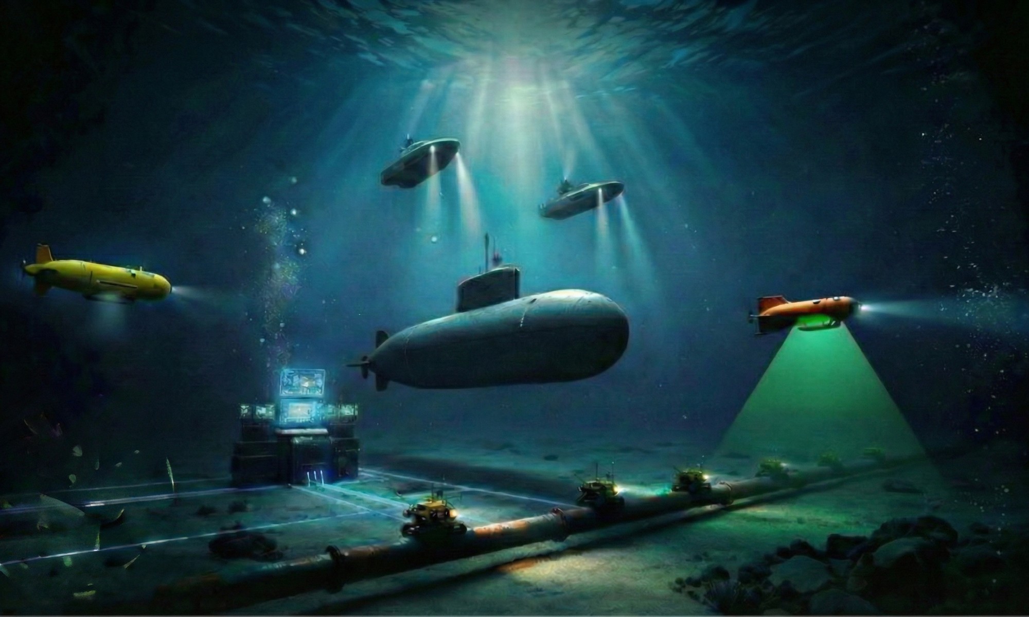
At its core is a symbiotic USV–AUV concept: Unmanned Surface Vehicles
acting as autonomous motherships, supporting and sustaining fleets of
Autonomous Underwater Vehicles.
This does not concern replacing ships with drones. It is about
breaking the endurance barrier and creating a system where at least one
AUV is always in the water – surveying, mapping, and monitoring critical
infrastructure – while others recharge, upload data, or stand by.
Persistence becomes the standard, not the exception.
The
Operational Principle: Continuous AUV Rotation
The model is simple yet operationally effective. A USV deploys a
fully charged AUV to survey a defined CUI corridor. As that AUV
approaches its battery or mission limit, it autonomously returns to the
USV. A launch-and-recovery system (LARS) enables safe, automated
docking, often without the AUV even leaving the water. While the
returning vehicle recharges and offloads data, a second AUV is deployed
immediately.
The result is a continuous rotation cycle: 1 – one AUV surveying; 2 –
one AUV charging; 3 – one AUV processing or standing by. There are no
surveillance gaps, no need for crewed recovery, and no dependence on
weather windows to dictate operational tempo. This capability
establishes the USV as an effective force-multiplying mothership.
The most critical function of the USV in this architecture is launch
and recovery, rather than navigation or endurance. A multi-AUV LARS
transforms the USV from a basic platform into an autonomous subsea
operations hub. It enables safe handling of multiple AUVs in real sea
states; in-water docking for charging and data transfer; and elimination
of deck-based recovery, the riskiest phase of any subsea mission.
Removing personnel from launch and recovery operations significantly
increases safety. Meanwhile keeping AUVs submerged during servicing
further increases operational uptime. In this case persistence is no
longer limited by weather, daylight, or crew availability.
AUVs: High-Resolution
Eyes on the Seabed
In this model, the AUV serves as the primary sensor platform,
operating directly where CUI is located. Medium-class AUVs offer an
optimal balance of payload capacity, endurance, and autonomy for
monitoring infrastructure. Equipped with high-resolution sonar, such as
Synthetic Aperture Sonar (SAS), they deliver centimeter-scale imagery
across wide areas of the seabed. This level of resolution is essential,
not optional.
It enables detection of subtle seabed disturbances, newly introduced
objects, cable exposure, or burial changes, and provides evidence of
tampering or pre-positioned devices. Importantly, it also enables
repeatable and comparable surveys, supporting accurate pattern-of-life
analysis along critical routes.
From Seabed to
Shore: Turning Data into Decisions
Persistence alone is insufficient; data must be transferred securely
and efficiently. In the USV–AUV model, data flows seamlessly: 1 – raw
sonar data is collected by the AUV; 2 – data is transferred during
docking to the USV; 3 – data is then pre-processed onboard to flag
anomalies and reduce bandwidth; 4 – pre-processed data is transmitted
via encrypted satellite links to shore-based command centres.
The USV acts as a mobile data gateway, providing near-real-time
intelligence to national or alliance-level command systems. Once
integrated into a wider Maritime Domain Awareness framework, this
continuous data stream enables a shift from reactive response to
proactive infrastructure defense.
Strategic
Advantages That Redefine the Mission
The benefits of this symbiotic model are transformational, not
incremental.
Persistence at Scale: Weeks or months of uninterrupted monitoring
replace short, disconnected missions; Reduced Risk: No crews are exposed
to hazardous launch and recovery operations; Operational Discretion:
Low-profile USVs and submerged AUVs significantly reduce detectability;
Economic Viability: Replacing crewed support vessels with autonomous
motherships makes persistent surveillance financially viable;
Scalability: Multiple USV–AUV teams can be deployed simultaneously
throughout vast infrastructure networks.
Together, these advantages make unmanned systems a significant force
multiplier for CUI protection.
A New Doctrine for
Underwater Security
The protection of Critical Underwater Infrastructure is no longer a
niche technical problem, it’s a strategic requirement. The USV–AUV
mothership model offers a forward-looking doctrine – one designed for
endurance, ambiguity, and scale. By making sure that there is always an
AUV in the water, it delivers the persistence required to deter, detect,
and document hostile activity in the subsea domain.
"Always One AUV in the water (Thomas Meurling – Photoshop and Nano Banana Pro)
While this model is highly relevant for CUI, its implications reach
further to mine countermeasures, ISR, and long-term seabed monitoring.
At a time when underwater infrastructure has become both a target and a
strategic lever, adopting persistent, unmanned, and integrated
surveillance architectures is no longer optional. It’s the new baseline
for maritime security.
Call-To-Action
Please comment so we all can learn from each other.
Hydrography has always been about one thing. Reducing uncertainty
before uncertainty becomes expensive.
The Egyptians understood that. Long before sonar, they were already
measuring water levels and restoring order after the Nile floods wiped
out boundaries and infrastructure. Their tools were simple, but the
principle was powerful. Measure carefully. Repeat consistently. Turn
water from chaos into something you can manage.
That, in essence, is still hydrography.
[Video: Evolution of Hydrographic]
For centuries, the lead line was the main tool of the trade. A
weighted rope lowered to the bottom. One depth point. One moment in
time. If you were lucky, a little tallow on the lead would also bring up
mud or sand, giving you a clue about bottom type. It worked. Sort of.
But it was painfully slow, highly manual, and left enormous gaps between
soundings. In other words, it gave you information directly under the
vessel and a healthy amount of optimism everywhere else.
Then came the fathometer.
Fathometer (singlebeam echosounder)
In the 1920s, echo sounding changed the game by allowing surveyors to
measure depth acoustically while underway. This was a major step
forward. No more dropping a line over the side every few minutes. Now we
could collect a continuous depth profile along track. Productivity
jumped. Confidence improved. But there was still a problem. A
single-beam echo sounder only looks straight down. It tells you what is
below the keel, not what is waiting a few meters off to port. Or
starboard. Or directly in the gap between survey lines where nasty
surprises like to hide.
That is why multibeam mattered so much.
Multibeam did not just improve hydrography. It changed the question.
We stopped asking, “What is the depth under me?” and started asking,
“What does the entire seabed look like across my swath?” That is a very
different level of ambition. And it is the reason hydrography moved from
sparse measurement to true seafloor mapping.
One of the important commercial milestones in that transition was the
SeaBat 9001. It helped bring multibeam out of the realm of specialist
systems and into practical survey operations. Compact. Commercial.
Usable. It made it possible for more operators to move from isolated
soundings to real swath bathymetry. That was a big deal. Once people saw
proper coverage, going back to sparse data felt a bit like going from
radar to binoculars and calling it progress.
Illustration of SeaBat 9001 bottom detection (recreated)
Then came the systems I know personally.
I had the privilege of helping to lead the development of the SeaBat
8125 and, later, the 7125 as R&D Manager for RESON Inc. The SeaBat
8125 was based on Jens Steenstrup’s (co-founder of RESON) brilliant
ideas, with Mark and Kirk as lead engineers. This was a major leap in
shallow-water hydrography. It delivered extremely high resolution, using
focused beamforming, and helped redefine what surveyors expected from
multibeam performance in ports, harbors, and coastal approaches. It was
not just about measuring depth better. It was about seeing the seabed
with a level of clarity that changed operational standards.
The 7125 took that further. Dual-frequency capability. Greater
flexibility. Better coverage. More productivity. Better data in more
conditions. This is where multibeam matured from a clever sonar into a
true survey system. When operators can reduce infill lines, maintain
data quality, and get cleaner results faster, that is not a small
engineering improvement. That is commercial and operational
leverage.
And then we arrive at the SeaBat T20 & T50.
The T20 & T50 represent the next stage in the evolution.
Frequency agility. Advanced beamforming and better sidelobe suppression,
resulting in cleaner bathymetry.
Better integration with inertial navigation. Higher data density.
Less time fighting artifacts in post-processing. In simple terms, it
reflects where hydrography has been heading all along. Not just toward
more data, but toward better data. Data you can trust. Data that
shortens the path from acquisition to decision.
SeaBat T51 (credit Teledyne RESON)
That is really the story here.
The evolution of hydrographic survey is not just a story of better
sensors. It is the story of reducing ambiguity. From Egyptian
measurement staffs to lead lines. From lead lines to fathometers. From
fathometers to multibeam. From multibeam to agile, high-resolution
systems like the SeaBat T50/T51.
I give the examples of SeaBat sonar family, as that is what I’m most
familiar with. Similar MBES to T50/T51 would be Norbit Winghead or
Kongsberg EM 2042, all excellent MBES systems
We no longer just sample the seabed. We model it. We interpret it. We
operationalize it.
And that is a very good thing.
Because the ocean has always been unforgiving to people who confuse
limited data with real understanding.
Call-To-Action
Please comment and provide insight so we all can learn from each
other. Did you ever used any of the older SeaBat MBES systems?
Modern warships cost billions, and tankers carry valuable cargo.
Global energy markets rely on predictable sea lanes. Yet a relatively
cheap mine ($1500), deployed by a fishing boat or patrol craft, can
disrupt strategy, spike insurance, halt traffic, and unsettle both
military leaders and markets.
That is the genius of the mine. It does not need to sink a fleet. It
only needs to create doubt.
And in a chokepoint like the Strait of Hormuz, doubt is operationally
contagious.
Strait of Hormuz
This is where geography stops being background and becomes a weapon.
On paper, the Strait looks wide enough. In reality, commercial traffic
is funneled into narrow traffic lanes, which means a small number of
mines can create disproportionate disruption. This is not just a naval
problem. It is a global trade problem with a sonar solution attached to
it.
The Threat Profile Is
Built for Asymmetry
The mine threat in a chokepoint is not one thing. That is where many
simplified conversations go wrong.
You are not dealing with a single neat category of weapon. You are
dealing with a layered threat set. Classic contact mines remain
dangerous because they are cheap, simple, and psychologically effective.
Bottom influence mines are more sophisticated and far more selective,
using magnetic, acoustic, and pressure signatures to wait for the right
target. Then you have rising mines, which turn the seabed into an ambush
position and compress reaction time to almost nothing.
This matters because each mine type creates a different tactical
problem. One threatens the hull. Another threatens confidence. The third
threatens timelines.
And the environment helps the defender. Variable bathymetry,
cluttered seafloor, internal wave activity, coastal traffic, and
shallow-to-moderate littoral conditions create exactly the kind of messy
operating picture that mine warfare loves. Mines do not need perfect
hiding places. They only need enough ambiguity to slow you down.
That is the real weapon here. Delay.
Iranian Naval Mines
A minefield in a chokepoint functions not only as an obstacle but as
a negotiation tool backed by explosives.
The Solution Is Not
Heroics. It Is a System
Mine countermeasures once relied heavily on courageous personnel
performing hazardous tasks in dangerous environments. This approach
deserves respect but not nostalgia.
The modern answer is layered, robotic, persistent, and frankly far
less sentimental.
First, you need domain awareness before the mines go in. Persistent
surveillance matters because clandestine minelaying often hides inside
normal maritime traffic. Pattern-of-life analysis, long-endurance
unmanned systems, and AI-assisted anomaly detection are no longer nice
extras. They are the front line of prevention. If you can identify the
craft, route, timing, and behavior associated with mine deployment, you
are not just clearing mines. You are shutting the faucet before the
floor floods.
Second, once the threat is in the water, you need a detect-to-engage
chain that keeps sailors outside the live minefield. This is where
unmanned surface and airborne systems earn their keep. Airborne laser
systems can search the water column quickly for moored threats. Unmanned
sweep systems can trigger influence mines by pretending to be the kind
of ship the mine wants to kill. Expendable neutralizers can then
prosecute confirmed targets without asking a diver to become the last
part of the kill chain.
That is the strategic shift. Not just finding mines, but
industrializing the process of dealing with them.
Because in real mine warfare, speed matters, but confidence matters
more. One missed mine can reopen the crisis.
The
AQS-20C Sonar System Deserves Its Own Conversation
If you are serious about modern minehunting, you cannot talk only
about platforms. You have to talk about payloads. And specifically, you
have to talk about the AN/AQS-20C.
This is not just another towfish. It is one of the more serious
answers to the mine problem because it combines multiple sensing modes
into one operational package. Towed by the Common Unmanned Surface
Vehicle, the AQS-20C brings side-looking synthetic aperture sonar,
forward-looking sonar, a gap-filler capability for the nadir zone, and
an electro-optical laser imaging function for shallow and near-surface
identification.
That matters for a simple reason. Mines are opportunists, and blind
spots are invitations.
Traditional minehunting involves tradeoffs: range versus detail,
imagery versus speed, coverage versus gaps beneath sensors. The AQS-20C
addresses these by combining multiple detection and classification
functions in a single pass. In mine warfare, this enhances survival,
tempo, and clearance probability.
AN/AQS20 Sonar System
Combined with the CUSV, this system provides critical standoff
capability. The vehicle operates in shallow littoral waters, tows
substantial payloads, and maintains endurance. This shifts risk by
advancing sensors and platforms while keeping sailors at a safer
distance.
That is how it should be.
Mine warfare is among the least glamorous naval operations. Clearing
shipping lanes slowly and methodically lacks heroism but is
strategically critical. Without reopening sea lanes, discussions of sea
control become hollow.
Final Ping
The mine threat is not impressive because it is advanced. It is
impressive because it is efficient.
That is why the answer cannot be a single ship, a single sonar, or a
single brilliant operator. It has to be a layered architecture of
surveillance, unmanned systems, advanced sensing, deception, and precise
neutralization. The side that wins mine warfare is usually the side that
understands two things first: chokepoints amplify fear, and fear travels
faster than any fleet.
Sea mines are cheap. Strategic paralysis is not.
And that is exactly why systems like the CUSV and the AQS-20C matter
so much. They do not just find mines. They help restore freedom of
movement, which in maritime terms is another way of saying they help
restore leverage.
Because in the end, the mission is not to admire the threat.
It is to make it irrelevant.
Call-To-Action
Please share your comments and insights so we can all learn from one
another.