The Great Undersea Awakening: Atlantic Bastion and the Ocean That Refuses to Be Quiet

The Great Undersea Awakening: Atlantic Bastion and the Ocean That Refuses to Be Quiet

Executive summary

Atlantic Bastion represents an ambitious shift in how the Royal Navy intends to protect the North Atlantic: connecting autonomous systems, underwater sensors, ships, and aircraft into a more persistent maritime defense network. Its promise is earlier warning, better understanding and a more effective response to underwater threats.

For me, this project is personal. I was involved while at Ocean Power Technologies. Watching it develop brings both enthusiasm and some familiar questions about what it takes to turn an ambitious concept into something that survives contact with salt water.

The comparison with the Cold War’s SOSUS listening network is compelling, although Atlantic Bastion should not be presented as its direct replacement or the first mobile anti-submarine warfare network. The opportunity lies in combining persistence, mobility, autonomy and shared information on a much broader scale.

And its success will depend heavily on a deceptively simple question: have we put the right payload on the right platform for the job?


The North Atlantic is a difficult customer

It does not read your strategy document. It has little interest in your investor presentation. And it certainly will not reduce the wave height because your demonstration is scheduled for Thursday.

That is part of what makes Atlantic Bastion so interesting.

There is real ambition here: a maritime surveillance architecture that can keep more sensors at sea, connect their observations, and help naval forces understand what is happening beneath the surface.

Having been involved from the bidding side, I feel a personal connection to that ambition. I want to see it succeed. I also want the discussion to reach beyond the attractive graphics of autonomous vessels connected by immaculate blue lines.

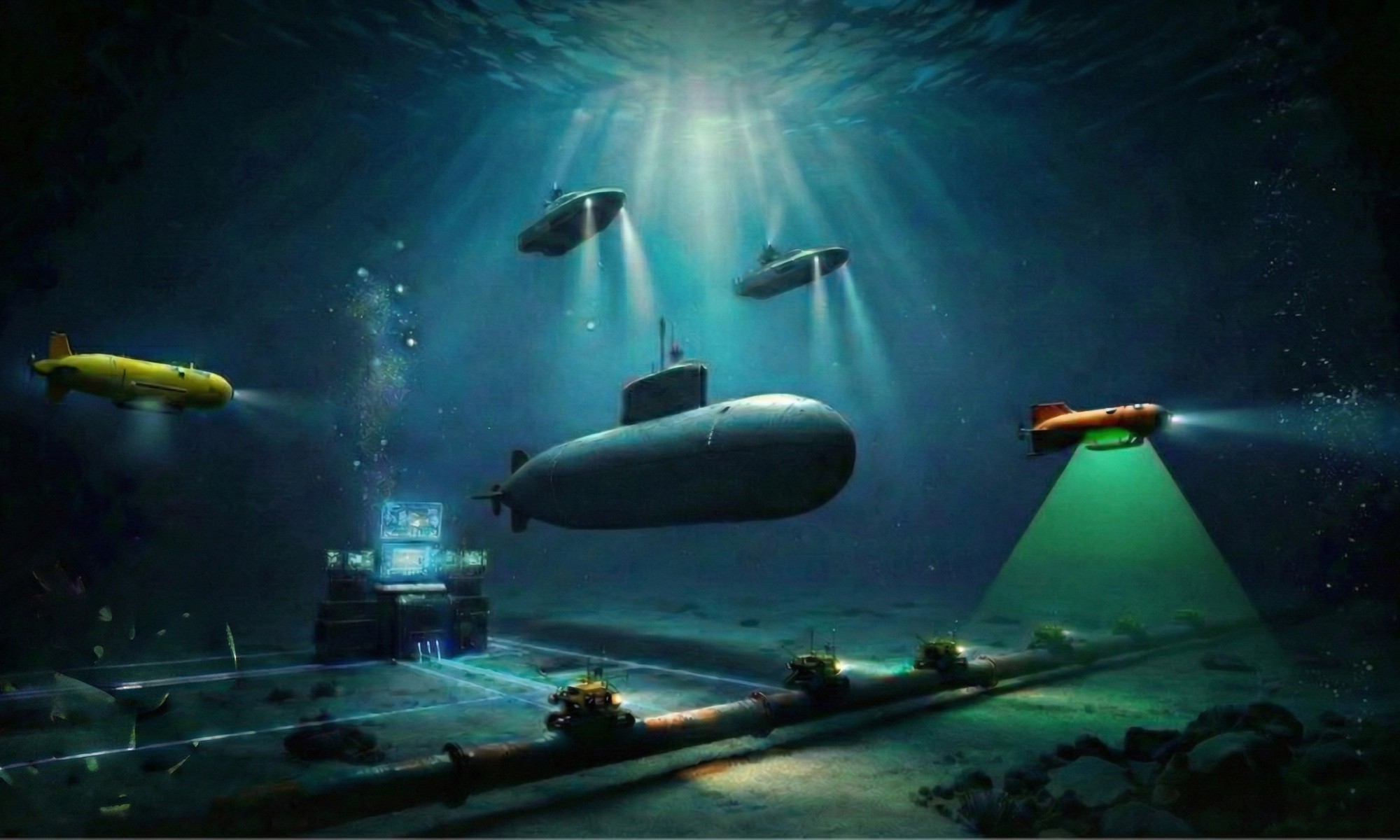
Atlantic Bastion (Thomas Meurling - Photoshop and Nano Banana Pro)
Atlantic Bastion (Thomas Meurling – Photoshop and Nano Banana Pro)

Those lines have an enormous amount of engineering hidden inside them.

The strategic purpose is serious. In September 2026, the First Sea Lord described Atlantic Bastion as a defensive network supporting protection of the UK’s continuous at-sea deterrent and critical infrastructure. That places it directly in the business of protecting the connections and capabilities on which national security depends.

For everyone ashore who considers maritime security a specialist interest, remember this: an impressive amount of modern life depends on things crossing an ocean or sitting on its bottom.

The seabed deserves more attention than it gets.


SOSUS

The historical echo takes us back to SOSUS: the Sound Surveillance System and the geography of the Greenland–Iceland–UK gap.

SOSUS used fixed underwater hydrophone arrays to exploit the ocean’s ability to carry sound over long distances. It became a much wider surveillance network than a single line across the North Atlantic. The principle was powerful: listen persistently, use the environment intelligently, and turn faint acoustic information into useful awareness.

Original SOSUS networks (Thomas Meurling – Photoshop and Nano Banana Pro)

It is tempting to call Atlantic Bastion “SOSUS with autonomy.”

As a conversation starter, that works. As a technical description, it needs another cup of coffee (or would that be tea…?)

Mobile surveillance already has a substantial history. The US Navy developed SURTASS, the Surveillance Towed Array Sensor System, using ships to tow long acoustic arrays. DARPA’s own history describes work that helped advance that capability decades ago.

Atlantic Bastion therefore enters a long-running story. What excites me is the ambition to make a varied collection of autonomous and crewed systems function as a persistent, adaptable network.

Atlantic Bastion Network (Thomas Meurling – Photoshop and Nano Banana Pro)

Think of a listening architecture with more moving parts, more opportunities to reposition sensing and a much greater need for everything to understand one another.

That last requirement could become the most expensive sentence in the program.


Concept

So, what does the concept actually do?

In April 2026, the Royal Navy described demonstrations covering seabed acoustic detection, uncrewed surface vessels with acoustic and towed arrays, remote operations centers, AI integration, drones carrying sonobuoys, subsea vehicles, gliders and acoustic floats. These were demonstrations of technologies that could contribute to the capability; they were not proof that every component had already become one fully operational network.

The functional logic is straightforward enough.

Different sensors contribute different observations. Those observations need to be assessed, combined, and placed in context. People then need information clear enough to decide whether something deserves further investigation or a response.

A detection is the beginning of that process.

It still leaves questions: what produced it, how confident are we, does another observation support it, and what should happen next?

My concern is that we could become very good at collecting information without becoming equally good at understanding it. A crowded display can look reassuringly sophisticated while leaving its operator thoroughly unconvinced.


More sensors should buy us better decisions. We should insist on evidence that they do

One recent development illustrates why the less glamorous parts matter.

In September 2026, the Royal Navy reported that five Slocum G3 gliders had completed a 64-day mission gathering environmental data around the British Isles. The service explicitly linked this work to Atlantic Bastion. Their contribution was oceanographic understanding; the announcement did not say these gliders had spent two months autonomously hunting submarines.

That distinction deserves attention.

Temperature, salinity and pressure affect sound speed in seawater. Understanding those conditions helps explain how acoustic observations should be interpreted.

A sensor operates inside an environment, and that environment gets a vote.

You can put artificial intelligence on the processing chain, but you cannot persuade the ocean to adopt your preferred acoustic conditions.

The environmental glider may never win the beauty contest against an autonomous submarine. Its measurements can still be essential to making the rest of the system useful.

There is another interesting change below the surface of the procurement language.

The Ministry of Defence’s May 2025 Atlantic Net pipeline notice proposed delivering “ASW as a service” through a Contractor Owned, Contractor Operated, Naval Oversight model. It described industry-provided systems supplying acoustic data, triaged by AI and machine learning, to a secure remote operations center for Royal Navy analysis.

That approach could create room for faster deployment and technology refresh.

It also makes the service definition critically important. What counts as useful availability? What happens when equipment needs recovery? How is data quality demonstrated? Who carries responsibility when several suppliers’ systems disagree?

Calling something a service does not make the maintenance disappear. Somewhere, someone still has to deal with a connector that has developed an intimate relationship with seawater.

From a bid manager’s perspective, these are exactly the questions that make an ambitious proposition concrete.

From a sonar consultant’s perspective, they bring us back to the payload.

The most expensive sonar you can buy is the wrong sonar.

An excellent sensor can become a poor investment when it is mismatched to the mission, platform or operating environment. The vehicle’s motion, its own noise, available power, payload space and practical support arrangements all need attention.

Then there is endurance.

The platform, sensor, processor, and communications equipment all arrive at the same electrical dinner table. Their combined appetite deserves examination before anyone promises how long the system will remain useful offshore.

We should also distinguish time at sea from time delivering dependable information.

A vehicle can remain afloat while its contribution deteriorates. Maintenance, calibration, data quality, and recovery arrangements deserve a place beside autonomy in the sales presentation.

I would like to hear more conversations begin with the decision the customer needs to make, followed by the information needed to support it. That gives us a sensible route toward selecting the sensor and its platform.

Starting with a favorite vehicle and searching for a mission afterward is an expensive way to go boating.

This is why I see Atlantic Bastion as such an important undertaking. It creates an opportunity to rethink how persistent maritime awareness is delivered while exposing every difficult seam between platforms, payloads, processing, people, and support.

My test of success would be practical: does it deliver useful coverage, trustworthy information, and a dependable service under real operating conditions?

Those are less photogenic measures than a new autonomous hull. They are also the measures that will matter when the weather deteriorates and the contact becomes ambiguous.


Summary

Atlantic Bastion carries forward the enduring logic of undersea surveillance into a more connected, autonomous era. Its promise is substantial, and its delivery will demand disciplined integration, environmental understanding, and reliable support. My personal involvement makes this a project I will follow with particular interest. The ocean will provide the most honest progress report.

At Strategic Sonar Solutions Inc., I help customers select the right payload for their autonomous or crewed platforms, starting with the mission, the operating environment, and the decisions the system must support.

If you are developing a platform, evaluating sonar options, or reconsidering an existing payload, message me here on LinkedIn. Let’s discuss what your platform needs to detect, understand, and deliver before you commit to the equipment.

The North Atlantic will test the result. Let’s give it something worth listening to.


Originally published in the Strategic Pings ))) newsletter on LinkedIn on 2026-09-30. Subscribe there to get new editions first.

Seabed 2030: Big Plans for an Ocean We Still Haven’t Properly Mapped

Seabed 2030: Big Plans for an Ocean We Still Haven’t Properly Mapped

Executive Summary

A patch of blue on a map is an excellent way to make an information gap look reassuring.

My background in hydrography, including my work with RESON and Teledyne, has made me rather less reassured. Beneath that blue are mountains, channels, habitats and hazards that influence real decisions. Understanding this underwater landscape matters deeply to me.

As of April 2026, 28.7% of the world’s ocean floor had been mapped to modern standards. We are planning the ocean’s future with most of its geography still missing from the detailed picture.

GEBCO_2026 grid - Robinson World Projection - displaying mapped regions in blue. New additions to the GEBCO Grid in the 2026 release highlighted in red.
GEBCO_2026 grid – Robinson World Projection – displaying mapped regions in blue. New additions to the GEBCO Grid in the 2026 release highlighted in red.

Seabed 2030 gives us a shared ambition: a complete, freely available seabed map. Delivering it requires funding, coordination, technical expertise, and access to existing data.

Hydrography asks a wonderfully uncomfortable question: How do you actually know what is beneath you?

Eventually, someone has to produce the measurements. A beautifully rendered digital ocean will only get you so far.

The Nippon Foundation–GEBCO Seabed 2030 Project launched in 2017, when only 6% of the seabed was mapped to adequate resolution. The progress deserves recognition.

But progress and sufficient progress are different things.

Coverage increased from 27.3% in 2025 to 28.7% in 2026, adding almost five million square kilometers. An enormous contribution—and just 1.4 percentage points against the global task.

At that annual rate, closing the remaining gap would take roughly 51 years. That is simple arithmetic, not a forecast: investment, technology, and the release of existing datasets could substantially change the pace.

2030 needs a serious acceleration plan behind it.

One obstacle is that many people assume the job is already done.

Open a digital globe and the ocean floor looks complete. Ridges, trenches, contours: very convincing. Across vast areas, however, that picture relies on low-resolution estimates derived from satellite data rather than detailed seabed measurements.

Seabed 2030 progress (Thomas Meurling – Photoshop and Nano Banana Pro)

An attractive color palette is doing a remarkable amount of work.

For readers outside hydrography, a multibeam echo sounder measures returning sound across a broad strip beneath a vessel, building a picture of depth and terrain. Bringing sensors closer to the seabed, including aboard autonomous underwater vehicles, can reveal finer detail in deep water.

The principle is straightforward. Reliable results take expertise.

Position, vessel motion, sound speed, and calibration all matter. The seabed has declined to rearrange itself to match our assumptions.

We also need to be precise about “mapped.” Seabed 2030’s target grid-cell sizes range from 100 meters in shallower waters to 800 meters in the deepest ocean. Individual engineering and inspection tasks require their own survey specifications.

GEBCO explicitly states that its grids must not be used for navigation or other purposes involving safety at sea.

A global map is a foundation. Understanding its limitations is part of using it intelligently.

Autonomy can expand our mapping capacity. Uncrewed surface vessels carry survey systems across extensive areas, while underwater vehicles bring sensors closer to terrain requiring detailed investigation.

But removing the crew does not remove the need for hydrographic competence.

Someone must plan the survey, integrate the sensors, validate the measurements, and deliver usable information. My preferred measure of success is the cost of delivering a square kilometer of usable, quality-controlled coverage.

Less glamorous than unveiling another autonomous vessel. Considerably more useful when discussing the budget.

There is also valuable information sitting in archives. Some gaps in the global compilation reflect measurements already collected but not contributed. Seabed 2030 seeks these datasets and encourages reduced-resolution sharing where commercial sensitivities are involved.

Summary

Before commissioning another survey, check what someone already knows.

Organizations can take three practical steps:

Review existing datasets: establish ownership, permissions and potential value to the global map.Plan contributions into new surveys: agree on sharing arrangements while teams and budgets are in place.Fund expertise alongside equipment: skilled people turn sensor output into information others can trust.

Seabed 2030 Commitments (Thomas Meurling - Photoshop and Nano Banana Pro)
Seabed 2030 Commitments (Thomas Meurling – Photoshop and Nano Banana Pro)

Seabed knowledge supports ocean circulation research, tsunami modelling, environmental management, and cable routing. Its value extends far beyond our industry.

For me, Seabed 2030 is a professional responsibility with a personal connection. My work with RESON and Teledyne is part of why I care about turning acoustic measurements into useful knowledge.

We have capable technology. Closing the gaps requires sustained investment, shared data and people who understand the mission.

At Strategic Sonar Solution Inc., I help clients define sonar requirements, evaluate technologies and plan sensor integration for conventional and autonomous platforms. Contact me to discuss your survey ambitions, assess your options, and build a practical path from operational need to reliable seabed information.

Scanning the depths so you don’t sail blind.


Originally published in the Strategic Pings ))) newsletter on LinkedIn on 2026-09-21. Subscribe there to get new editions first.

The Minehunter Is Dead: What Belgium and the Netherlands Got Right About Autonomous MCM

The Minehunter Is Dead: What Belgium and the Netherlands Got Right About Autonomous MCM

Executive Summary

The Belgian-Dutch replacement Mine Countermeasures program is much more than a procurement of twelve new ships. It represents a fundamental change in how navies detect, classify, identify and neutralize mines.

The traditional minehunter sails into the suspected minefield with a hull-mounted sonar. The new concept keeps the mothership outside the danger area and sends an integrated team of uncrewed surface vessels, autonomous underwater vehicles, towed sonars and mine-disposal systems forward.

I followed this competition from the uncomfortable side of the table.

As bid manager for Teledyne Marine, I spent considerable time in Ghent working with Elbit and a REMUS-based AUV concept. We wanted to win. We believed we had strong sensors, capable vehicles and a credible technical solution.

We lost.

What won was not necessarily the best individual sonar, AUV or USV. ECA Group and Naval Group presented the most convincing complete operational system. That distinction remains one of the most important lessons in autonomous maritime procurement.

Replacing the Traditional Minehunter

Belgium and the Netherlands had operated closely related Tripartite and Alkmaar-class minehunters for decades. These ships represented the classic MCM model: place a specialized vessel near the mine threat, search with hull-mounted sonar, investigate contacts and deploy a disposal vehicle.

The replacement program was far more ambitious.

The two navies wanted twelve new MCM vessels, six for each country, supported by roughly one hundred uncrewed systems. The ships would become command platforms, workshops, data-processing centers, and launch-and-recovery motherships rather than traditional minehunters.

That sounds logical today. In 2019, it was a bold procurement decision.

During the bid phase, Ghent became one of my temporary offices. Meetings focused on payload capacity, sonar performance, navigation accuracy, launch and recovery, data processing, endurance and system integration. Every supplier had impressive slides. Every team could produce attractive detection ranges.

But a minefield does not care about PowerPoint.

A successful MCM operation requires a complete chain. The vehicle must navigate accurately. The sonar must produce usable imagery. The software must manage contacts. The operator must distinguish a mine-like object from another tire, cable, rock or discarded refrigerator. A second system must relocate the target. A third must neutralize it.

One weak link can make the entire architecture operationally irrelevant.

Who Won?

In 2019, the contract was awarded to Belgium Naval & Robotics, the consortium formed by Naval Group and ECA Group. Naval Group led the vessel and combat-system element. ECA Group supplied the integrated robotic MCM toolbox.

ECA Group later combined with iXblue under the Exail name. In July 2026, Thales announced a binding agreement to acquire the Gorgé family’s controlling stake in Exail and launch a tender offer for the whole company. The transaction is not yet complete, so Exail is on course to become part of Thales rather than already being fully absorbed.

It has been quite a journey.

ECA was once viewed as a specialist robotics company competing against much larger defense groups. Its success in Belgium and the Netherlands helped prove that maritime robotics had moved from equipment demonstrations into fleet-level naval architecture.

Why ECA Won

The detailed tender scoring has not been publicly released, so claims about one decisive technical score would be speculation.

The winning logic, however, is visible in the architecture.

ECA did not merely offer an AUV. It offered a coordinated toolbox built around the Inspector 125 USV, A18-M AUV, T18-M towed sonar, Seascan identification vehicle, K-Ster C disposal system, influence-sweeping equipment and UMISOFT mission-management software.

Belgium MCM Mothership and ECA MCM Toolbox (Thomas Meurling - Photoshop and Nano Banana Pro)
Belgium MCM Mothership and ECA MCM Toolbox (Thomas Meurling – Photoshop and Nano Banana Pro)

The Inspector 125 became the forward-deployed carrier. It could transport sensors and disposal vehicles into the mine-threat area while the larger crewed vessel remained farther away.

That created genuine stand-off MCM.

More importantly, ECA understood that integration included launch and recovery, navigation, communications, mission planning, contact management and neutralization. The customer was not being asked to buy a collection of excellent boxes and then spend years persuading them to communicate.

That was the impressive part of the win. (and they had Daniel S. as bid manager…)

The Sonar Architecture

The A18-M AUV uses the UMISAS 120 interferometric synthetic aperture sonar for autonomous mine detection and classification. The vehicle can survey an area independently, collecting consistent, high-resolution acoustic imagery without requiring a physical communications link to the surface platform.

The T18-M towed system performs a related mission using the UMISAS 240 sonar. Because it remains connected to the Inspector 125, its sonar data can be transmitted in real time through the USV to the command ship.

ECA (EXAIL), MCM UMIS TOOLBOX (Credit ECA/EXAIL, modified with Photoshop and Nano Banana Pro)

This combination matters.

The AUV provides autonomous coverage and freedom of movement. The towed sonar provides continuous communications, immediate quality control and faster operator intervention. They are not competing solutions. They address different parts of the same mission.

After detection comes identification. Seascan relocates and inspects the contact using cameras and forward-looking sonar. K-Ster C then performs the neutralization task while sailors remain outside the immediate danger zone.

The sonar is therefore not a payload hanging under a vehicle. It is part of a sensor-to-decision chain.

That is where many autonomous programs still get it wrong.

Current Status

The first vessel, Belgium’s M940 Oostendevehicles,, was officially transferred to the Belgian Defense organization on November 7, 2025.

M940 Oostende (Credit Belgian Navy, edited with Photoshop)

The second vessel, HNLMS Vlissingen, was delivered to the Royal Netherlands Navy in Den Helder on February 27, 2026.

The first operational MCM toolbox has also been delivered in Zeebrugge. It includes Inspector 125 USVs, A18-M AUVs, Seascan and K-Ster vehicles, with the T18-M towed sonar element scheduled as part of the continuing delivery sequence. Further vessels are under construction, with deliveries planned to continue through 2030.

The program has moved beyond drawings, prototypes and promotional videos. Hardware is entering naval service.

The harder phase now begins: qualification, doctrine development, crew training, maintenance, data management and proving that the complete kill chain works under real operational conditions.

Summary: The Lesson From Ghent

I would naturally have preferred a different result when I was sitting in Ghent working on the Teledyne, Elbit and REMUS-based proposal.

But losing a major competition can teach you more than winning an easy one.

The Belgian-Dutch program demonstrated that customers do not ultimately buy sonar specifications, vehicle endurance or attractive autonomy demonstrations. They buy confidence that the complete mission will work.

ECA understood that early. Naval Group gave the robotic architecture a credible mothership and naval integration framework. Together, they changed the definition of a minehunter.

The new minehunter is no longer a ship.

It is a distributed system of sensors, vehicles, communications, software, operators and weapons. The sonar starts the conversation, but integration determines whether the mine is actually removed.

Because buying an excellent sonar is relatively easy.

Building an operational capability around it is where the real work begins.

Call To Action

Selecting a sonar is easy. Selecting the right sensor for the right payload, the right autonomous platform, and the right mission is much harder.

Strategic Sonar Solutions Inc. helps navies, shipyards, defense companies, investors, and autonomous-system developers make those decisions with less risk and fewer expensive integration mistakes.

If you are evaluating sonar, AUV, USV, ROV, MCM, ASW, hydrographic, or seabed-warfare capabilities, contact me. Let’s make sure the system works as a complete mission solution, not just as an impressive collection of specifications.


Originally published in the Strategic Pings ))) newsletter on LinkedIn on 2026-09-16. Subscribe there to get new editions first.

Strategic Ping: Sweden’s French Connection, and the Acoustic Battle for the Baltic

Strategic Ping: Sweden’s French Connection, and the Acoustic Battle for the Baltic

Executive summary

Sweden has signed a roughly SEK 47 billion contract with Naval Group for four FDI-based Luleå-class frigates, scheduled for delivery between 2030 and 2034.

The headline is French frigates. The more important story is Swedish pragmatism and underwater warfare.

A proven platform reduces construction risk, but it does not guarantee ASW superiority. In the Baltic’s shallow, noisy and highly stratified waters, success will depend on how well Sweden integrates sonar, environmental intelligence, helicopters and autonomous systems.

A mature frigate can shorten the route to sea. It cannot repeal the laws of underwater acoustics.

The calendar is also a weapon

Sweden’s order covers HMS Luleå, HMS Norrköping, HMS Trelleborg and HMS Halmstad. The contract value includes training systems, spares and associated equipment, so simply dividing SEK 47 billion by four does not produce a meaningful unit price.

More strategically, Sweden is joining an established FDI production line and an operator community that already includes France and Greece.

That matters. Sweden is choosing operational relevance within a critical timeframe over the prestige and risk of another clean-sheet national design. I see this from a personal perspective.

Visby Stealth Corvette -Project name YS2000 (Credit SAAB and Thomas Meurling w/Photoshop Pro)

I was part of the YS2000 design team at FMV that developed the YS2000/Visby class. The original YSS/Luleå concept was intended to become its larger sibling. Selecting the FDI therefore represents more than a platform decision. It marks a significant departure from the design lineage Sweden originally envisioned.

CAPTION: Sweden Frigate Pivot from National Concept to French Proven Design (Credit: Naval Tech and SAAB, modified by Thomas Meurling w/Photoshop and Nano Banana Pro)

Industrial sovereignty sounds magnificent in a strategy document. It sounds less magnificent when the fleet is still waiting at the pier.

The Baltic is an acoustic nightmare

The Baltic covers approximately 420,000 square kilometers, yet more than one-third is shallower than 30 meters. Salinity ranges from roughly 15–18 PSU near the entrance to the Sound, to 7–8 PSU in the Baltic Proper and as little as 0–2 PSU farther north and east.

Those differences, together with temperature variations, create layers that can bend sound away from a sonar (refraction). The Baltic is famous for what is called “micro-sound channels”.

Baltic Sea difficult hydro-acoustic environment (Thomas Meurling – Nano Banana Pro)

Now add dense shipping, machinery noise, bottom reverberation, complicated coastlines and quiet conventional submarines. The result is an environment where catalog performance and operational performance may be very different things.

Thales advertises detection ranges of up to 60 kilometers and beyond for the CAPTAS sonar family. That demonstrates potential, not certainty. In ASW, the words “up to” can carry more displacement than the ship.

What the FDI brings below the waterline

The established FDI ASW architecture offers a sound foundation. The Greek configuration combines the Kingklip Mk2 hull-mounted sonar with the CAPTAS-4 Compact variable-depth sonar.

Sweden has publicly identified ASW as a core Luleå-class capability, but it has not yet named the final sonar suite. Kingklip and CAPTAS should therefore be treated as the reference architecture, not automatically as the confirmed Swedish fit.

Hull-mounted and Variable Depth Sonar (credit THALES and modified by Thomas Meurling)

A hull-mounted sonar provides immediate coverage, but it remains fixed at hull depth and must contend with the ship’s own noise. A variable-depth sonar can be lowered through the water column, allowing operators to place it on the useful side of a temperature or salinity layer.

That flexibility comes at a price. The ship must accommodate the towed body, cable, winch, power, cooling, maintenance and launch-and-recovery loads. Sea state, maneuvering and crew workload also matter.

The sonar may fit beautifully in a brochure. The handling system still has to fit in the ship.

The network is the real ASW weapon

The Luleå class should not be judged only by the performance of its onboard sonar. Its greater value may be its ability to coordinate a distributed underwater sensor network.

Ship sonar, helicopter dipping sonar, sonobuoys, maritime patrol aircraft, uncrewed surface vessels and autonomous underwater vehicles such as AUV 62R, can create multiple sensing positions. One platform can transmit while another listens. Autonomous systems can extend coverage or enter areas where exposing a crewed frigate would be unwise.

This is where sensor fusion becomes decisive. More sensors do not automatically create more understanding. Without robust communications, compatible data formats, accurate environmental models and manageable operator workloads, they may simply create more ambiguity at greater expense.

A SEK 47 billion ship can still lose the acoustic fight if payload integration is treated as an accessory.

The strategic wager

Sweden is betting that a mature foreign hull, selective national integration and a wider operator community will deliver combat power sooner than a sovereign clean-sheet program.

That is a sensible wager.

But the ASW test will not be passed when the ship leaves the yard. It will be passed when the frigate can enter a difficult acoustic environment, coordinate manned and autonomous sensors, maintain contact on a quiet submarine and convert uncertain detections into a reliable tactical picture.

Short summary

The hull gets the Navy to sea. The sensor architecture determines what it can hear when it arrives.

Sweden has reduced platform risk. Its next challenge is ensuring that sonar, payloads, data fusion, and operating concepts work as one ASW system in the difficult Baltic environment.

Selecting a maritime sensor payload?

I help clients select and integrate sonar, surveillance and mission payloads for autonomous and manned platforms, matching the technology to the mission, platform and operating environment.

If your program needs an independent view before committing to a payload architecture, connect with me on LinkedIn or send me a message.

The costliest sensor mistake is often not buying bad technology. It is buying good technology for the wrong mission.


Originally published in the Strategic Pings ))) newsletter on LinkedIn on 2026-09-08. Subscribe there to get new editions first.

The Silent Sentinels: How Motherships and Sonar are Rewriting the Rules of Seabed Warfare

The Silent Sentinels: How Motherships and Sonar are Rewriting the Rules of Seabed Warfare

Executive Summary: The Subsurface Paradigm Shift

The maritime domain is witnessing a seismic shift in the subsurface balance of power. The transition from traditional, crewed mine-hunting to autonomous, mothership-led operations is not merely a tactical upgrade; it is a maritime revolution. In the current geopolitical climate, where critical undersea infrastructure (CUI) is the lifeblood of global trade and energy, the old methods of mine countermeasures are as antiquated as a sextant in a satellite world. This shift is the only logical response to increasingly sophisticated, integrated, and autonomous underwater threats that seek to plunge our global economy into the dark of the littoral.

The core value proposition of the “Mothership” concept represents a departure from single-mission hulls toward versatile, high-capacity nerve centers:

Tactical Mass and Standoff: By deploying a “brood” of autonomous systems, the Mothership allows sailors to stay well outside the minefield’s lethal radius while robots handle the “dirty, dull, and dangerous” labor of neutralization.Strategic Flexibility: As evidenced by the HMS Stirling Castle’s delivery of mission kit for the Strait of Hormuz, these vessels are not just platforms; they are logistics powerhouses capable of projecting power across the globe at a moment’s notice.Allied Resilience: Codified through the UK-Norway alliance, the shift toward modular, shared designs like the Kongsberg C2 Vanguard ensures a unified, interoperable force protects that NATO’s Northern Flank.

Navigating this transition requires more than just new hardware; it requires a fundamental change in how we perceive naval presence. We are moving from a world of ships to a world of data-driven sensors.


The Mother ship: From Commercial Workhorse to Naval Nerve Center

Repurposing commercial offshore support vessels (OSVs) like the Island Crown into the HMS Stirling Castle is the height of maritime pragmatism. In a blue-water environment where procurement cycles often move at a glacial pace, the Royal Navy (RN) has cut through the fog by acquiring hulls already optimized for subsea engineering. Some landlubbers have criticized the ship’s initial civilian paint scheme as “unprofessional” or “sketchy,” but to the veteran strategist, this was a triumph of utility over vanity—a grey-paint soul in a civilian skin, serving as a trials platform before her full military refit.

HMS Stirling Castle , USVs, AUVs and ROVs (Thomas Meurling – Photoshop and Nano Banana Pro

Technical Profile: HMS Stirling Castle (M01)

The table below is the technical profile foHMS Sterling Castle

HMS Sterling Castle Profile

The transition of the Stirling Castle from the Royal Fleet Auxiliary (RFA) to the RN was not an aesthetic choice; it was driven by a “manpower storm.” With the RFA effectively on its last legs due to a “deeply troubling” crewing crisis, the RN had to take the helm to ensure the ship didn’t sit idle. This move marks the Stirling Castle as a dedicated commissioned warship, shifting from a mere trials boat to a strategic host for a new breed of Deep Armada.


The Autonomous Armada: Deploying the Drones of the Deep

The Mothership’s true strength is her ability to facilitate “distributed maritime operations.” She acts as a floating base for an armada that operates beyond the horizon, ensuring that if a drone is lost to a sophisticated mine, the loss is measured in pounds and pence, not lives. The Stirling Castle’s recent delivery of four mine-hunting vessels to Gibraltar for a possible operation in the Strait of Hormuz proves this adaptability—she is a mobile hangar for the underwater front line.

The autonomous armada supported by the Stirling Castle consists of four primary pillars:

Autonomous Underwater Vehicles (AUVs): The REMUS family is the gold standard here. Notably, the REMUS 300 serves as the baseline for the U.S. Navy’s Lionfish program, and we are now seeing these assets tested for submarine torpedo-tube launch, allowing for clandestine deployment from the depths.Unmanned Surface Vehicles (USVs): The ROMULUS family and RNMBs like Apollo and Hazard provide the surface-level coordination, acting as AI-enabled relays for the swarm below.Remotely Operated Vehicles (ROVs): Essential for high-stakes neutralization, these systems allow human operators to perform subsea surgery on fuzed threats from the safety of the Mothership’s mission bay.Modular Mission Payloads: Future-proofing is baked into the design. The “plug-and-play” nature of these platforms means we can swap sensors as fast as thethreat evolves, ensuring the hull remains relevant for decades.

The Saab Multi-Shot Mine Neutralization System (MuMNS) deployed from USV (Naval Technology and Thomas Meurling)

While the physical drones are impressive, they are merely delivery vehicles for the most valuable asset in seabed warfare: high-resolution sonar data.


Sonar Technology: The Strategic Advantage of High-Resolution Imagery

In the contested dark of the littoral, data is the only currency with any real value. To detect a mine designed to look like a rock or a fuzed device hidden near a communications cable, you need more than just a ping; you need a “digital twin” of the seafloor. This is where the Royal Navy gains its decisive edge, utilizing open-architecture sonar systems that can be rapidly upgraded to meet new fuzing challenges.

The REMUS Sonar Family provides a tiered capability that defines modern seabed mapping:

REMUS 130/300: These are the agile scouts. Optimized for shallow-water and rapid deployment, they provide immediate situational awareness in the most cluttered environments.REMUS 620: The workhorse of persistent surveillance. With an 110-hour battery life and a 275nm range, it can map vast swathes of the seabed, providing the persistent “eyes” required for infrastructure protection.

The REMUS 300 with Marine Sonic Sidescan and REMUS 620 with KRAKEN SAS Sonar (Photo collage by Thomas Meurling – Photoshop and Nano Banana Pro)

This tech isn’t bought blindly. The Dstl (Defence Science and Technology Laboratory) utilized rapid 3D physical modeling to de-risk the procurement of the Stirling Castle, identifying a “key design change” early in the process. This marriage of advanced sonar and analytical de-risking ensures that every byte of data gathered is an investment in maritime security.


The Geopolitical Deep: NATO, Norway, and the North Atlantic

The “Lunna House Agreement” between the UK and Norway is the cornerstone of NATO’s Northern Flank. This isn’t just about joint exercises; it’s about a total integration of defense. From pre-storing British equipment on Norwegian soil to conducting Arctic training across all seasons, the alliance is focused on one thing: ensuring the North Atlantic remains a NATO lake.

Luna House Agreement (Thomas Meurling – Photoshop and CathGPT)

The joint procurement strategy, currently assessing the Kongsberg C2 Vanguard design for the next three motherships, offers profound strategic benefits:

Lifecycle Efficiency: Shared design means shared spare parts and training pipelines, reducing the fiscal burden while increasing “combat mass.”Interoperability: A Norwegian USV must be able to launch from a British deck without friction. Modular standards make this a reality.Procurement De-risking: By joining Norway’s standardized vessel program, the UK avoids the “bespoke trap,” getting proven hardware into the water faster.

The future of naval power in the High North is no longer about who has the biggest gun, but who has the most resilient sensor network.


Conclusion: Navigating the Future with Strategic Sonar Solutions

The era of the traditional, specialized minehunter is ending, and the era of the Mothership has begun. The HMS Stirling Castle is not merely a ship; she is a harbinger. To ignore this transition toward autonomous, sensor-driven warfare is to choose obsolescence. Maritime leaders must decide now: will you adapt to the new subsurface paradigm, or will you let the tide of technology leave you stranded?

Contact Strategic Sonar Solutions today. In the murky waters of modern maritime strategy, you need a guide who has seen the transition from the keel up. Whether you are navigating sonar integration, autonomous platform deployment, or the complexities of seabed warfare, we provide the authoritative insights needed to secure your undersea advantage. The ocean floor is the new front line; make sure you have the eyes to see it.


Originally published in the Strategic Pings ))) newsletter on LinkedIn on 2026-09-01. Subscribe there to get new editions first.